 |
| Click on this image for our track in Google Maps |
Much later than usual because... reasons.
Sure, I could tell you tales on how giving stuff away for free, as well as being relatively successful at it, does seem to attract a surprisingly large number of people who aren't going to be wishing you well and who may instead try everything they can to precipitate your downfall, and how fending off said people can end up eating a solid chunk of what should otherwise have been a quiet Sunday afternoon.
But, even as I may touch on the more unpleasant aspects of being a (somewhat) prominent Free Software developer eventually, I am not planning to spend more time on this specific topic today.
Still, this late start might be a blessing in disguise as the skies cleared up something beautiful by mid-afternoon (we had sea-mist accompanied by dense low clouds until then), which provides us with a much better light for pictures. Besides, with June squarely upon us at last, we don't have to worry about arriving too late, as the sun is not gonna set for a very, very long time indeed.
Thus, as we arrive for our second public foray into Inishowen, this time towards the Urris Hills, the weather couldn't be better. As with almost every afternoon for the past few weeks, the temperature is well above 20°C, which, for hillwalking, does qualify as "hot".
 |
| Bog cotton (Eriophorum angustifolium), with Urris Hills in the distance |
Plus, that gorgeous field of aptly named "bog cotton", pictured above, is all it really takes to make us forget the unpleasantness we were battling against earlier. It is therefore with a firm and decided foot that we undertake our climb of this most welcoming area of the Inishowen peninsula.
 |
| Another view of Urris Hills as we start our climb |
Now, having done this climb from various starting points, I'll start by giving you this pointer: While it may look inviting, don't bother starting from the beach at the foot of Fort Dunree. If you do, you'll have a somewhat large stream to cross plus some small boulder fields to negotiate at the foothills as well as, when in season, a maze of high ferns.
The much smarter option is to drive a bit further up the road, and park wherever seems appropriate there. Then you can head north towards the hills and enjoy a much friendlier initial path. There's more than enough of Urris to climb even if you start a little higher so, unless you are really up to an extra bit of challenge, you don't have to force yourself through the small annoyances that may otherwise dampen your overall enjoyment of the place.
 |
| Dunree Hill, along with the beach from which you don't really want to start your climb |
Not that this climb is really challenging anyway, especially in this kind of weather. As such, through one of the many sheep tracks that lead to it, we have soon reached the walking path that follows the ridge, a ridge that is already providing us with astounding views of Swilly Bay and Fanad Peninsula behind it.
 |
| Swilly Bay, glistening under the late afternoon sun |
Still, with all this afternoon light at our finger tips, we're going to leave the track and push a bit further north than Crockfadda (NB: In case you wonder why we seem to be climbing a different Crockfadda every other day, I'll clarify this small mystery by revealing that "fadda" means "long" in Irish and thus about every relatively "long" peak you find is going to be named that way) to see what we get. And it isn't long before we collect our rewards, starting with the quiet cove of Lehan Bay, replete with its small fishing boat fleet, as well as the unmistakable profile of Dunaff Head further north:
 |
| The quiet waters of Lehan Bay, with Dunaff Head in the distance |
I should also mention that, ever since we reached the ridge, we have been accompanied by a most welcome coastal breeze, which decidedly makes our progress all the more enjoyable as we zip along from rocks, to tall grass, to dense heather, and bask into every other great view we can get.
 |
| Looking towards Fort Dunree and Fanad's Knockalla Mountains |
Yet, since we are here, we cannot fail to make a small detour to one of the various WW2 crash sites you find dotted around County Donegal, the location of which I set with a marker on the hiking map above.
 |
| The W5653 crash site and memorial |
This unfortunate crash site and memorial happens to be for a Wellington Mk.VIII plane (ID: W5653), that belonged to Limavady's 221 squadron, and that went down on April 11th 1941 because of thick mist/low clouds, instantaneously killing its 6 crew members. You'll find the plaque bearing the names of all the individuals who perished here, in the additional pictures below.
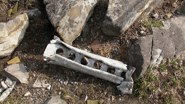
As is usual for the remote crash sites of County Donegal, if do you walk around the memorial site, part of which is actually made from remnants of the aircraft, you can still find bits and pieces of the dismembered aircraft lying around, which makes for a sobering thought, especially considering the contrasting beauty of this place on a day like today...
 |
| A piece of the Wellington Mk.VIII aircraft, that crashed here on April 11th 1940 |
Since there is no easy transition to make, and after sparing a thought for the young crew that perished there, we simply leave the crash site and head for the small valley that opens behind it.
Soon enough, but not before we've inadvertently got one leg completely burrowed through a treacherous and hidden ground hole (as a hillwalker these deep vertical burrows are about the only hazard you meet in these parts) we have reached the second one of our hike's planned waypoints: Lough Fad.
 |
| Lough Fad, as seen from its western shore |
This lake may be slightly difficult to access (or, at the very least, sufficiently well hidden from the beaten track), but it is a most pleasant sight in its own right, especially as the rocky ranges sitting on either side help convey a most definitive sense of tranquillity. However, this seclusion is not without its drawbacks as, through convenient sheltering from the sea breeze, the lake also appears to be home to a fair amount of mosquitoes, as we soon discover...
Yet, the ones we meet do not appear to be the annoying kind: they get chased quite easily and don't seem to want to come back, even as we have decided that we might get a well deserved snack on these shores:
 |
| Not much to be unhappy about, on the shores of Lough Fad (though I sometimes wish my excessive appetite for these cookies was a "fad" too...) |
And thus, with a stomach now appeased, we continue our merry way towards the northern ridge. Already, because of the much later time for our hike, we are getting a most striking display of Fanad and Rossguill in the sunset, as the sea mist is beginning to make some ground inland:
 |
| Ballyhoorisky Point and Melmore Head under the golden sunlight |
Then, not long after we left the previous one, we reach the shores of a second lake: Crunlough
 |
| The rocky face of Urris Hills, reflected in Crunlough |
After going round the lake, and feeling that we've ventured far away enough through the hills (sure, we could still have climbed Croachcarragh, but it does feel like we've been out long enough), we head back towards the high ridge and start making our long way towards our departure point, as the skies seem to agree that it's probably time to put an end to our walk by beginning to get somewhat overcast.
From the high ridge we catch views of Lough Fad and Crun from a different perspective (seen in the additional pictures below) but, more importantly, of Fanad, shining like a golden bracelet under the setting sun.
 |
| What did I tell you about skies always being clear over Fanad? |
Indeed, by now, it no longer matters how unpleasantly our afternoon started. The only thing we feel like saying, from contemplating the spectacle offered to us in this late hour, can only be: all in all it was a pretty good day...
Suggested Sound Track
Since that last line and our post's hook come straight from it, and Scarlet's Walk (from which this track is issued) is the album I was listening to while driving towards Urris Hills, this seems like an obvious choice. Besides, even if I don't know what takes hold, it sorta feels like you guys might use a little Tori in your lives...


